LBS Quick Start
Location Based Services (LBS) provides location information for installed applications and for remote services via a network. Location information can be used for location stamping artefacts such as photographs and memos, finding nearby services and facilities, navigation, and the ability for remote parties to discover the user's whereabouts.
Location-based services (LBS) use coordinates from the World Geodetic System (WGS 84), which is also used as a reference system by the Global Positioning System (GPS).
The coordinates are based on values for latitude, longitude, and altitude (elevation above sea level).
The North Pole is 90 degrees North (+90 degrees) and the South Pole is 90 degrees South (-90 degrees). The Equator is defined as 0 degrees; locations above it have positive latitudes (0 to +90 degrees); those below (0 to -90 degrees) negative ones.
There are two definitions of North Pole; Magnetic North Pole and True (Geographical) North Pole. Any application with a compass must check how the API defines North Pole.
The Magnetic North Pole is the point to which compasses point. The True North Pole defines latitude as +90 degrees.
Meridians are constant longitudinal (north-south) values. The Prime (Greenwich) Meridian’s value is 0 degrees. WGS84, which LBS use, defines its zero meridian some 100 meters east of the Prime one. Locations east of the Prime Meridian have positive longitudinal values (0 to +180 degrees), those west (0 to -180 degrees) have negative ones.
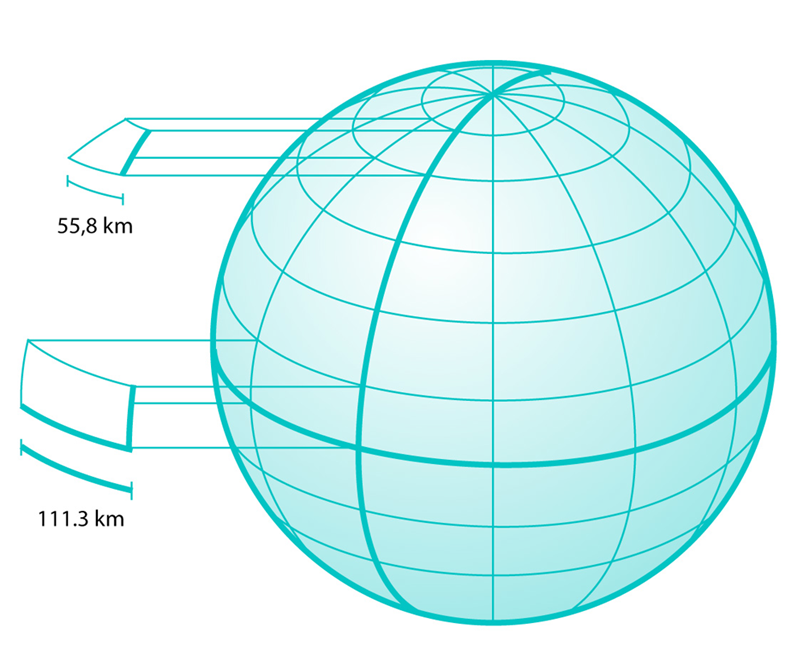
As seen in the figure below, latitude lines are smaller near the poles. At the equator, one degree of longitude is roughly 111.3 km, whereas at 60 degrees of latitude one degree of longitude is only 55.8 km, which is more difficult to see.
Getting started with LBS
This section provides links to the most important documentation.
For application developers
The Location Acquisition API is the interface that programmers use to create location-aware applications. The API gives developers the ability to get location fixes and to obtain information about the positioning technologies available to the mobile device.
Technologies
The main technologies enabled on the Symbian platform by the LBS subsystem are as follows:
-
Global Positioning System (GPS)
The GPS system provides accurate, worldwide positioning. The main disadvantage of GPS is the long time required to obtain a position fix when the GPS hardware is first powered. LBS supports Assisted GPS (A-GPS) to reduce the time required to get a position fix.
-
Network based positioning
Network based positioning is typically less accurate than GPS, but often provides a faster fix of adequate accuracy for some applications.
-
Secure User Plane Location (SUPL) v1.0
SUPL defines an architecture for supporting Location Based Services using IP bearers to connect handsets and network hosts. The Symbian LBS subsystem contains a SUPL Protocol Module to support SUPL.
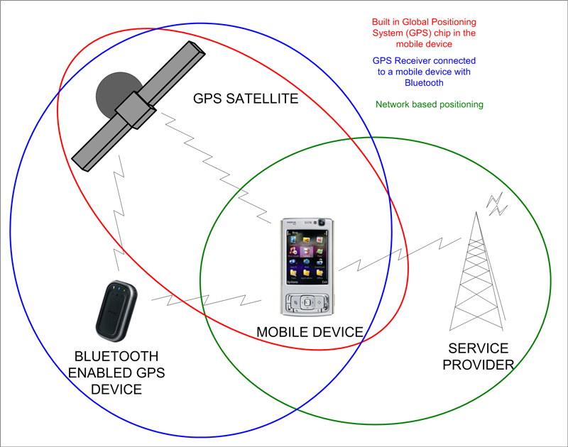
The above figure illustrates how the location information can be provided to the device. Access to these location methods is provided through the positioning modules.
Copyright ©2010 Nokia Corporation and/or its subsidiary(-ies).
All rights
reserved. Unless otherwise stated, these materials are provided under the terms of the Eclipse Public License
v1.0.